Transportation network modeling
data-driven simulation, routing and optimization
DESCRIPTION
Transportation network models are central to transportation operations and planning. There are two main components: network vehicle/passenger flow and travel behavior. The flow model describes flow propagation through the network arcs/nodes. The behavioral models encapsulate travelers’ time-of-day choices on routes, departure time, parking locations and traffic modes (such as solo-driving, carpool, transit, ride-sharing etc.). The idea is to infer/learn dynamic origin-destination (O-D) demands and behavioral choice models that altogether, if input into network simulations, would produce the spatio-temporal flows in the network consistent with the real-world multi-source data.

Data-driven large-scale network simulation and optimization
FEATURED PROJECTS
Team: Sean Qian (PI, CMU), Xidong Pi (CMU), Wei Ma (CMU)
Funding source: Traffic 21, Mobility 21 National University Transportation Center
Start/End time: 2017-2018
A CSX intermodal rail terminal is planned to open in late 2017 on a parcel of land located immediately north of the McKees Rocks Bridge in the Borough of McKees Rocks and Stowe Township, PA. The development will consist of an intermodal facility that will accommodate approximately 50,000 lifts per year opening year (2018) and 136,000 lifts per year at full buildout (2023). Access to the terminal is proposed via an improved Michael Alley to Island Avenue (SR 0051). It is expected to generate a significant number of trucks in the Borough of McKees Rocks, which adds additional burdens on the existing roadway in the Borough. The terminal may bring in heavy congestion to individual roadway drivers. A traffic impact study was conducted indicating a minor congestion increase with the new infrastructure. This research project conducts an in-depth analysis of the potential traffic impact in high temporal and spatial resolutions. Using the data collected in the traffic impact study along with other relevant data sets possessed by CMU Mobility Data Analytics Center, we simulate individual cars and trucks, and model their route choices, travel time and mixed traffic flow conditions. The result includes the travel time, travel delay, vehicle-mile-traveled and emissions for each road segment and intersection by time of day. We will also examine the effectiveness of potential traffic management strategies, specifically West Carson Street Extension and truck routing.
Publication
- Sean Qian, Jia Li, Xiaopeng Li, Michael Zhang, Haizhong Wang (2017), “Modeling heterogeneous traffic flow: a pragmatic approach.” Transportation Research Part B, Vol.99, pp. 183-204. [URL]
Team: Sean Qian (PI, CMU), Shuguan Yang (CMU)
Funding source: U.S. Department of Transportation Federal Highway Administration
Start/End Time: 2016-2018
Standardize procedures of the usage of data in travel time reliability analyses
Team: Sean Qian (PI, CMU), Alex Jacquillat (Co-PI, CMU)
Funding source: Pennsylvania Infrastructure Technology Alliance
Start/End Time: 2017-2018
As of 2013, there were over 256 million private vehicles owned and operated in the United States. Estimates of the average cost to own, maintain, insure, and park a private vehicle ranges from $460 to $913 per month, an enormous economic and environmental burden. Those vehicles altogether generate on average 37 hours’ congestion per vehicle in the year of 2013. Sharing services, such as ridesharing and on-demand taxi systems (e.g., Uber and Lyft) offer the potential to meet travel needs that are substitutional to self-driving, which leads to significant savings of energy use and flow reduction. In turn, ridesharing can mitigate the costs, congestion and environmental impact of automobile transportation. More importantly, as they grow to represent a significant fraction of network flows, ridesharing systems can influence traffic flows in urban areas in order to improve infrastructure performance. In spite of great potential, sharing services are not provided optimally. Travelers (i.e., service demand) oftentimes have difficulty finding vehicles, or do so at high costs (e.g., Uber’s surge price). On the other hand, taxi/uber/lyft drivers (i.e., service supply) also face challenges to remain profitable, and can lose significant revenue opportunities through incomplete knowledge of traveler demand. This PITA research will address the mismatching among sharing service providers and consumers by proactively predicting traveler demand and sharing demand information to service providers, resulting in better service for travelers, better revenue opportunities for drivers, and better transportation infrastructure performance. In particular, partnering with Gridwise, a Pittsburgh-based startup company, the research team aim to develop predictive models from numerous input datasets that are likely to correlate with rideshare demand. The models will be trained and validated using data obtained from CMU Mobility Data Analytics Center (MAC) and the Gridwise platform, as well as other simulated “proxies” of this demand such as rideshare surge prices.
Team: Sean Qian (PI, CMU)
Funding source: U.S. Department of Transportation through National University Transportation Center (T-SET: Technologies for Safe and Efficient Transportation)
Start/End Time: 2017-2018
Team: Sean Qian (PI, CMU), Michael Zhang (Co-PI, UCDavis), Ram Rajagopal (CO-PI, Stanford), Shuguan Yang (CMU)
Funding source: Cyber-physical systems program, NSF
Start/End Time: 2015-2018
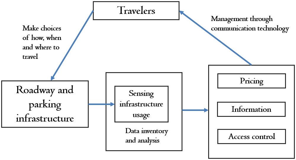
Parking can take up a significant amount of the trip costs (time and money) in urban travel. As such, it can considerably influence travelers’ choices of modes, locations, and time of travel. The advent of smart sensors, wireless communication, social media and big data analytics offers a unique opportunity to tap parking’s influence on travel to make the transportation system more efficient, cleaner, and more resilient. A cyber physical social system for parking is proposed to realize parking’s potential in achieving the above goals. This CPS consists of smart parking sensors, a parking and traffic data repository, parking management systems, and dynamic traffic flow control. If successful, the results of our investigation will create a new paradigm for managing parking to reduce traffic congestion, emissions and fuel consumption and to enhance system resilience. These results will be disseminated broadly through publications, workshops and seminars.
Our research probes massive individualized and infrastructure based traffic and parking data to gain a deeper understanding of travel and parking behavior, and develops a novel reservoir-based network flow model that lays the foundation for modeling the complex interactions between parking and traffic flow in large-scale transportation networks. The theories will be investigated at different levels of granularity to reveal how parking information and pricing mechanisms affect network flow in a competitive market of private and public parking. In addition, this research proposes closed-loop control mechanisms to enhance mobility and sustainability of urban networks. Prices, access and information of publicly owned on-street and off-street parking are dynamically controlled to: a) change day-to-day behavior of all commuters through day-to-day travel experience and/or online information systems; b) change travel behavior of a fraction of adaptive travelers on the fly who are aware of time-of-day parking information and comply to the recommendations; and c) influence the market prices of privately owned parking areas through a competitive parking market.
Publication
- Zhen (Sean) Qian and Ram Rajagopal (2015), “Optimal dynamic pricing for morning commute parking”, Transpormetrica A: Transport Science, Vol. 4(11), pp 291-316. [URL]
- Zhen (Sean) Qian, Ram Rajagopal (2014), “Optimal dynamic parking pricing for morning commute considering expected cruising time”, Transportation Research Part C, Vol. 48, pp. 468-490. [URL]
- Zhen (Sean) Qian and Michael Zhang (2011), “The economics of parking provision for the morning commute”, Transportation Research Part A, Vol.45(9), pp. 861-879. [URL]
Project page: Cyber-Physical System Virtual Organization Project Page
Award: NSF Award
Team: Sean Qian (PI, CMU), Xidong Pi (CMU)
Funding source: Pennsylvania Infrastructure Technology Alliance
Start/End Time: 2014-2015
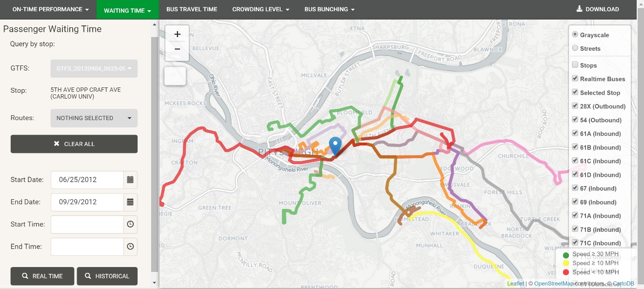
The essential idea is to fully utilize the big data in public transit to provide travelers fine-grained customizable information regarding transit service performance (efficiency, reliability and quality). By monitoring day-to-day transit service and how users respond to information provision, we can develop a better understanding of travelers’ preferences on efficiency, reliability and quality of transit service, as well as their modal choices. Big data and data-driven behavioral models facilitate agencies’ decision making (such as scheduling). Effective information provision, along with data-driven scheduling, holds great potential to improve the service performance and travelers’ riding experience.
Publication
- Xidong Pi, Sean Qian, Jackson Whitmore, Amy Silbermann (2017), “Understanding Transit System Performance Using APC/AVL Data: a Transit Data Analytics Platform With a Case Study for the Pittsburgh Region”, Journal of Public Transportation, accepted and forthcoming
Team: Sean Qian (PI, CMU), Wei Ma (CMU)
Funding source: Traffic21 Institute, Public Works of the City of Pittsburgh
Start/End time: 2015
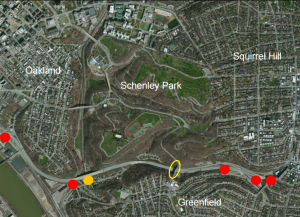
The Greenfield Bridge is planned to close for reconstruction in October 2015, and will remain closed for 18 months. This bridge currently carries a great deal of traffic, connecting the Greenfield neighborhood to Schenley Park. Given that there are no easy detour routes, traffic is likely to be disrupted. The Greenfield Bridge demolition and reconstruction project offers us a great opportunity to study the real-world impact caused by pre-planned incidents, and more importantly, to prepare the public agencies in Pittsburgh to deal more effectively with infrastructure failure. This project investigates how the Greenfield Bridge closures could affect highway traffic, arterials traffic, emissions and fuel consumptions. Potential transportation management strategies will be evaluated and recommended. This research requires extensive data collection, simulation modeling that takes into account time-of-day activity features, travel demand changes, departure time shifts (peak spreading), and traffic re-routing.
Publication
- Wei Ma and Sean Qian (2015), “Traffic impact of the Greenfield Bridge closure.” The Public Works of Pittsburgh Technical Report.
- Wei Ma, Sean Qian (2015), “Traffic impact of the Greenfield Bridge closure (AM peak).” submitted to the Department of Public Works, the City of Pittsburgh. [slides]
- Wei Ma, Sean Qian (2015), “Traffic impact of the Greenfield Bridge closure (PM peak).” submitted to the Department of Public Works, the City of Pittsburgh. [slides]
Team: Sean Qian (PI, CMU), Pinchao Zhang (CMU), Wei Ma (CMU)
Funding source: PennDOT, T-SET, Traffic 21
Start/End Time: 2014-2015
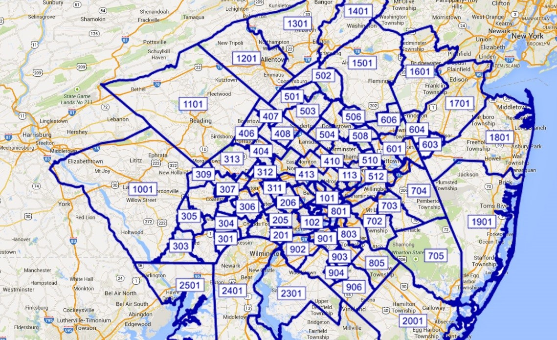
The Philadelphia Metropolitan Region is traffic data rich comparing to other metropolitan areas in the U.S. Various data sets in the Philadelphia region, including traditional traffic sensors (loops, cameras, etc.) and cutting-edge sensors (Bluetooth, GPS probe, parking, etc.), are available and have been archived for a decade. The rich data sets allow us to learn travelers’ behavior accurately and develop an in-depth understanding of non-recurrent traffic in large-scale networks. This research develops a regional dynamic network model that simulates millions of trips in the Philadelphia Metropolitan Region and captures those travelers’ travel behavior. It can be applied directly to predict traffic impact of planned and unplanned incidents, and provide real-time decision making for traffic operations. The regional model will also be tested as a real-time traffic management tool for two planned incidents, I-95 closures and Center City bridge closures.
Publication
Wei Ma, Pinchao Zhang and Sean Qian (2016), “Dynamic Network Analysis and Real-time Traffic Management for Philadelphia Metropolitan Area”, the Pennsylvania Department of Transportation (PennDOT). [URL]
